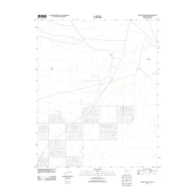
2011 Map of Mount Tipton NW
USGS Topo · Published 2011About this map
White Hills serves as the focal point of this high-desert region in Northwest Arizona, characterized by a grid-like street network that suggests planned residential development in a landscape defined by water scarcity and ranching heritage. The presence of Archibald Corral and various stock tanks, such as Flarea Tank and Barksdale Tank, indicates a landscape historically managed for livestock. To the east, the terrain rises toward the distinctive landform of Table Mountain. The settlement pattern is dominated by long, numbered thoroughfares like 17th St and 19th St, intersected by numerous named drives and roads including Mount Tipton Dr and Navajo Dr. Pierce Ferry Rd cuts diagonally across the northern portion of the map, serving as a primary transit corridor through the valley toward the Colorado River region to the north.
Find a feature on this map
67 named features on this map. Tap any name to fly to it.
Don’t see what you’re looking for? This feature index may not catch every label — zoom into the map to look around manually.
Map Details
Editions of this 2011 Mount Tipton NW Map
This is the sole edition of this map. No revisions or reprints were ever made.
Other maps of this area
1886 · Camp Mohave
USGS Topo · 1:250,000
1892 · Camp Mohave
USGS Topo · 1:250,000
1942 · Camp Mohave
USGS Topo · 1:250,000

1947 · Kingman
USGS Topo · 1:250,000

1948 · Kingman
USGS Topo · 1:250,000

1954 · Kingman
USGS Topo · 1:250,000

1955 · Kingman
USGS Topo · 1:250,000
1958 · Kingman
USGS Topo · 1:250,000
1960 · Kingman
USGS Topo · 1:250,000
1960 · Senator Mountain
USGS Topo · 1:62,500