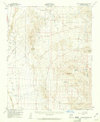
1960 Map of Senator Mountain
USGS Topo · Published 1961About this map
Mining operations and ranching infrastructure define this arid landscape within the Lake Mead National Recreation Area during the early 1960s. The topography is dominated by the high peaks of the Black Mountains, including Senator Mountain, Golden Rule Peak, and Squaw Peak, which overlook the broad expanse of the Detrital Valley to the west. Evidence of the region's mineral prospecting is found in the clusters of extraction sites such as the Senator Mine, Golden Rule Mine, and Fry Mine, along with the Owens Mine near the eastern boundary. Water management is critical in this desert environment, marked by features like North Senator Tank, South Senator Tank, and the Cyclopic Pumping Sta near Spear Ranch. A Pipeline and several Jeep Trails provide the primary means of navigating the terrain, connecting remote springs like Salt Spr and seasonal washes such as White Elephant Wash.
Find a feature on this map
32 named features on this map. Tap any name to fly to it.
Don’t see what you’re looking for? This feature index may not catch every label — zoom into the map to look around manually.
Map Details
Editions of this 1960 Senator Mountain Map
3 editions found
Other maps of this area

1886 · Camp Mohave
USGS Topo · 1:250,000

1886 · Saint Thomas
USGS Topo · 1:250,000

1892 · Camp Mohave
USGS Topo · 1:250,000

1893 · Saint Thomas
USGS Topo · 1:250,000

1926 · Nelson
USGS Topo · 1:96,000

1926 · Bonelli
USGS Topo · 1:96,000

1926 · Boulder Canyon
USGS Topo · 1:96,000

1942 · Camp Mohave
USGS Topo · 1:250,000

1947 · Kingman
USGS Topo · 1:250,000

1948 · Kingman
USGS Topo · 1:250,000