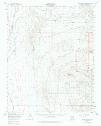
1960 Map of Senator Mountain
USGS Topo · Published 1983About this map
Detrital Valley and the surrounding desert peaks define this mid-century portrait of Mohave County, where the landscape transitions from broad washes to high mountain summits. Mining activity is central to the area's development, evidenced by the Senator Mine, Owens Mine, and Fry Mine clustered near the eastern ridges. These operations relied on a network of water sources in an otherwise arid environment, including the North Senator Tank and South Senator Tank, alongside the industrial infrastructure of the Cyclonic Pumping Sta. In the northern reaches, the Lake Mead National Recreation Area encompasses the Temple Bar Rapids, while the lower elevations are marked by the long stretch of the Temple Bar Road. The presence of the Spear Ranch and several springs like Eileen Spr highlight the sparse but vital human outposts that sustained ranching and prospecting in the region.
Find a feature on this map
22 named features on this map. Tap any name to fly to it.
Don’t see what you’re looking for? This feature index may not catch every label — zoom into the map to look around manually.
Map Details
Editions of this 1960 Senator Mountain Map
3 editions found
Other maps of this area

1886 · Camp Mohave
USGS Topo · 1:250,000

1886 · Saint Thomas
USGS Topo · 1:250,000

1892 · Camp Mohave
USGS Topo · 1:250,000

1893 · Saint Thomas
USGS Topo · 1:250,000

1926 · Nelson
USGS Topo · 1:96,000

1926 · Bonelli
USGS Topo · 1:96,000

1926 · Boulder Canyon
USGS Topo · 1:96,000

1942 · Camp Mohave
USGS Topo · 1:250,000

1947 · Kingman
USGS Topo · 1:250,000

1948 · Kingman
USGS Topo · 1:250,000