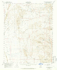
1960 Map of Senator Mountain
USGS Topo · Published 1966About this map
The high desert of the White Hills dominates this Mohave County landscape, where mineral extraction and remote ranching defined local activity in the mid-20th century. Mining operations are concentrated in the eastern reaches, including the Senator Mine, Fry Mine, and Owens Mine, situated along the drainages of White Elephant Wash. Water management is central to survival in this arid environment, evidenced by the Cyclopic Pumping Sta, North Senator Tank, and several named springs like Eileen Spr.
Find a feature on this map
49 named features on this map. Tap any name to fly to it.
Don’t see what you’re looking for? This feature index may not catch every label — zoom into the map to look around manually.
Map Details
Editions of this 1960 Senator Mountain Map
3 editions found
Other maps of this area

1886 · Camp Mohave
USGS Topo · 1:250,000

1886 · Saint Thomas
USGS Topo · 1:250,000

1892 · Camp Mohave
USGS Topo · 1:250,000

1893 · Saint Thomas
USGS Topo · 1:250,000

1926 · Nelson
USGS Topo · 1:96,000

1926 · Bonelli
USGS Topo · 1:96,000

1926 · Boulder Canyon
USGS Topo · 1:96,000

1942 · Camp Mohave
USGS Topo · 1:250,000

1947 · Kingman
USGS Topo · 1:250,000

1948 · Kingman
USGS Topo · 1:250,000