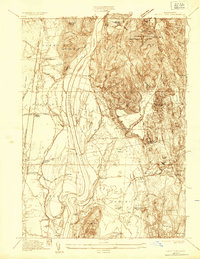
1935 Map of Mount Toby
USGS Topo · Published 1935About this map
The Connecticut River carves a deep valley through this 1935 survey, defining the boundaries of agricultural and forest land in Franklin and Hampshire counties. High ground is dominated by the Mt Toby Demonstration Forest and the dramatic elevations of North Sugarloaf Mtn and South Sugarloaf Mtn, which overlook the fertile bottomlands near Sunderland and Bradstreet. The landscape shows a region transitioning between rural farming and institutional development, evidenced by the presence of Massachusetts State College and the State Fish Hatcheries. Transportation networks are firmly established with the Boston And Maine RR and Central Vermont RY serving small depots like East Whately Station. From the isolated schoolhouses like Three Corners Sch to the industrial history suggested by Factory Hollow Pond, the map records the infrastructure of the Connecticut Valley before mid-century expansion.
Find a feature on this map
72 named features on this map. Tap any name to fly to it.
Don’t see what you’re looking for? This feature index may not catch every label — zoom into the map to look around manually.
Map Details
Editions of this 1935 Mount Toby Map
This is the sole edition of this map. No revisions or reprints were ever made.
Other maps of this area

1885 · Northampton
USGS Topo · 1:62,500

1886 · Northampton
USGS Topo · 1:62,500

1887 · Warwick
USGS Topo · 1:62,500

1887 · Belchertown
USGS Topo · 1:62,500

1889 · Warwick
USGS Topo · 1:62,500

1890 · Belchertown
USGS Topo · 1:62,500

1890 · Greenfield
USGS Topo · 1:62,500

1891 · Northampton
USGS Topo · 1:62,500

1893 · Northampton
USGS Topo · 1:62,500

1893 · Belchertown
USGS Topo · 1:62,500