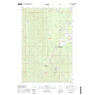
2020 Map of Mount Walker
USGS Topo · Published 2020About this map
Quilcene and its surrounding valleys are defined by the convergence of the Little Quilcene River and Big Quilcene River as they descend from the Olympic Mountains. This 2020 survey illustrates a community deeply tied to its geography and natural resources, notably featuring the Quilcene National Fish Hatchery and the Big Quilcene River Bridge. High peaks like Mt Walker and Green Mtn rise sharply from the river bottoms, while the eastern section shows the agricultural and residential corridors along Leland Valley Rd W and Center Rd. Genealogy researchers will find the Quilcene Cem documented near the river, while outdoors enthusiasts can trace the Lower Big Quilcene Trail and the passage through Notch Pass and Walker Pass. The map also details the extensive boundaries of the Olympic National Forest, covering the steep, creek-fed terrain of the Quilcene Range.
Find a feature on this map
77 named features on this map. Tap any name to fly to it.
Don’t see what you’re looking for? This feature index may not catch every label — zoom into the map to look around manually.
Map Details
Editions of this 2020 Mount Walker Map
This is the sole edition of this map. No revisions or reprints were ever made.
Other maps of this area

1936 · Point Misery
USGS Topo · 1:62,500

1938 · Mt Constance
USGS Topo · 1:125,000

1940 · Point Misery
USGS Topo · 1:62,500

1940 · Quilcene
USGS Topo · 1:62,500

1946 · Tyler Peak
USGS Topo · 1:62,500

1947 · The Brothers
USGS Topo · 1:62,500

1948 · Tyler Peak
USGS Topo · 1:62,500

1950 · The Brothers
USGS Topo · 1:62,500

1953 · Seabeck
USGS Topo · 1:24,000

1953 · Quilcene
USGS Topo · 1:24,000