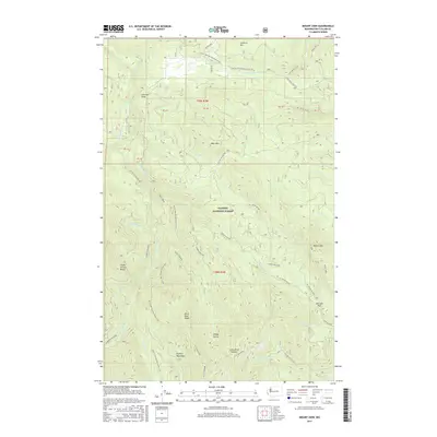
2017 Map of Mount Zion
USGS Topo · Published 2017About this map
Olympic National Forest land defines the character of this mountain quadrangle, dominated by the peaks and drainages of the eastern Olympic Mountains. The high ground of Mount Zion and Bear Mtn rises above a dense network of forest service roads and established wilderness paths, including a significant stretch of the Pacific NW National Scenic Trail. The landscape is carved by deep valleys like Sleepy Hollow and the headwaters of several key waterways including the Dungeness River, Jimmycomelately Cr, and the Little Quilcene River. Evidence of land management and surveying is visible through various numbered forest development roads and the distinct demarcations of PB 40 and other protraction blocks. Notable landmarks such as Bon Jon Pass and Schmith Knob serve as critical navigation points for those tracing the historic routes through these high-elevation corridors.
Find a feature on this map
50 named features on this map. Tap any name to fly to it.
Don’t see what you’re looking for? This feature index may not catch every label — zoom into the map to look around manually.
Map Details
Editions of this 2017 Mount Zion Map
This is the sole edition of this map. No revisions or reprints were ever made.
Other maps of this area

1938 · Mt Constance
USGS Topo · 1:125,000

1938 · Dungeness
USGS Topo · 1:62,500

1939 · Port Townsend
USGS Topo · 1:62,500

1939 · Dungeness
USGS Topo · 1:62,500

1940 · Quilcene
USGS Topo · 1:62,500

1946 · Tyler Peak
USGS Topo · 1:62,500

1948 · Tyler Peak
USGS Topo · 1:62,500

1953 · Mt. Walker
USGS Topo · 1:24,000
1953 · Uncas
USGS Topo · 1:24,000
1953 · Gardiner
USGS Topo · 1:24,000