
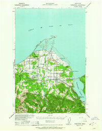
1939 Map of Port Townsend
USGS Topo · Published 1939About this map
Port Townsend sits at the strategic northeast corner of the Olympic Peninsula, anchored by the military presence of Fort Worden and the industrial activity of the National Paper Products Company at Glen Cove. This 1930s survey reveals a landscape defined by maritime defense and resource extraction, where the Milwaukee Road railroad lines connect small coastal settlements like Irondale and Hadlock. The interior is marked by significant land use, including the Cape George C C C Camp and several large military reservations.
Find a feature on this map
52 named features on this map. Tap any name to fly to it.
Don’t see what you’re looking for? This feature index may not catch every label — zoom into the map to look around manually.
Map Details
Editions of this 1939 Port Townsend Map
This is the sole edition of this map. No revisions or reprints were ever made.
Other maps of this area

1937 · Port Gamble
USGS Topo · 1:62,500

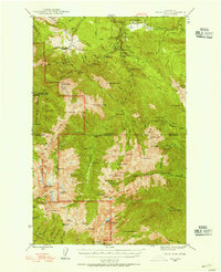
1938 · Mt Constance
USGS Topo · 1:125,000
1938 · Dungeness
USGS Topo · 1:62,500

1939 · Dungeness
USGS Topo · 1:62,500

1939 · Coupeville
USGS Topo · 1:62,500

1940 · Port Gamble
USGS Topo · 1:62,500

1940 · Quilcene
USGS Topo · 1:62,500

1943 · Richardson
USGS Topo · 1:62,500

1943 · Deception Pass
USGS Topo · 1:62,500
1946 · Tyler Peak
USGS Topo · 1:62,500