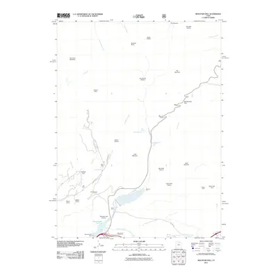
2011 Map of Mountain Dell
USGS Topo · Published 2011About this map
Mountain Dell Reservoir and the surrounding Wasatch Range terrain dominate this 2011 perspective of the canyons east of Salt Lake City. The landscape is defined by the critical drainage of Emigration Creek, a historic corridor marked by landmarks such as Last Camp and Brigham Fork. Modern land use is evident in the Mountain Dell Golf Course and the structural presence of the Mountain Dell Dam, while the surrounding slopes are etched with traditional routes like The Sheep Trl and Emigration Canyon Rd. Notable peaks and passes, including Big Mountain Pass and Lookout Peak, offer a clear view of the high-elevation geography that has historically funneled travel toward the valley. Smaller settlements and sites like Camp Grant, Kelvin Grove, and Maple Grove sit along the creek beds, illustrating the pockets of development within the rugged drainages of Killyon Canyon and Mountain Dell Canyon.
Find a feature on this map
44 named features on this map. Tap any name to fly to it.
Don’t see what you’re looking for? This feature index may not catch every label — zoom into the map to look around manually.
Map Details
Editions of this 2011 Mountain Dell Map
This is the sole edition of this map. No revisions or reprints were ever made.
Other maps of this area

1885 · Salt Lake
USGS Topo · 1:250,000

1925 · Ft. Douglas
USGS Topo · 1:125,000

1928 · Ft. Douglas
USGS Topo · 1:125,000

1950 · Fort Douglas
USGS Topo · 1:24,000

1951 · Fort Douglas
USGS Topo · 1:24,000

1952 · Sugar House
USGS Topo · 1:24,000

1952 · Bountiful Peak
USGS Topo · 1:24,000

1954 · Salt Lake City
USGS Topo · 1:250,000

1955 · Mount Aire
USGS Topo · 1:24,000

1955 · Park City West
USGS Topo · 1:24,000