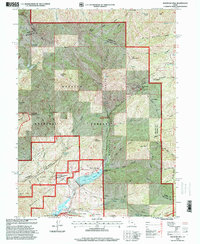
1998 Map of Mountain Dell
USGS Topo · Published 2001About this map
The Mormon Pioneers trail corridor serves as the historic backbone of this mountain terrain east of Salt Lake City, tracing a path through Emigration Canyon and over Big Mountain Pass. This late-1990s revision by the Forest Service highlights the intersection of pioneer history and modern recreation within the Wasatch National Forest. Notable commemorative sites like the Ephraim Hanks Station Pony Express Marker and the Mountain Dell Station Historic Marker provide tangible links to the 19th-century mail and migration routes. The landscape is further defined by the management of water resources, anchored by the Little Dell Reservoir and Mountain Dell Reservoir at the base of Little Mountain. While Pinecrest represents the residential footprint, the vast majority of the map focuses on protected research and recreation zones like the Red Butte Canyon Research Natural Area and the Mountain Dell Golf Course.
Find a feature on this map
55 named features on this map. Tap any name to fly to it.
Don’t see what you’re looking for? This feature index may not catch every label — zoom into the map to look around manually.
Map Details
Editions of this 1998 Mountain Dell Map
This is the sole edition of this map. No revisions or reprints were ever made.
Other maps of this area

1885 · Salt Lake
USGS Topo · 1:250,000

1925 · Ft. Douglas
USGS Topo · 1:125,000

1928 · Ft. Douglas
USGS Topo · 1:125,000

1950 · Fort Douglas
USGS Topo · 1:24,000

1951 · Fort Douglas
USGS Topo · 1:24,000

1952 · Sugar House
USGS Topo · 1:24,000

1952 · Bountiful Peak
USGS Topo · 1:24,000

1954 · Salt Lake City
USGS Topo · 1:250,000

1955 · Mount Aire
USGS Topo · 1:24,000

1955 · Park City West
USGS Topo · 1:24,000