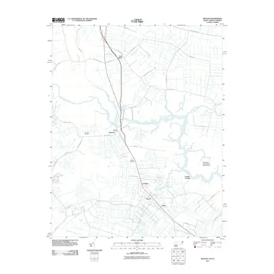
2011 Map of Moyock
USGS Topo · Published 2011About this map
Moyock and Saint Brides anchor this transition between the rural landscapes of southeastern Virginia and northeastern North Carolina. The Northwest River serves as the central hydrologic feature, winding through a complex network of wetlands that includes the Northwest River Marsh Wildlife Area and Panther Landing. The map reveals a settlement pattern influenced by early transport corridors, with nodes at Northwest, Morse, and Arringdale connected by historical routes like Ballahack Rd and Battlefield Blvd S.
Find a feature on this map
39 named features on this map. Tap any name to fly to it.
Don’t see what you’re looking for? This feature index may not catch every label — zoom into the map to look around manually.
Map Details
Editions of this 2011 Moyock Map
This is the sole edition of this map. No revisions or reprints were ever made.
Other maps of this area

1939 · Moyock
USGS Topo · 1:62,500

1940 · Lake Drummond
USGS Topo · 1:62,500

1940 · South Mills
USGS Topo · 1:62,500

1945 · Lake Drummond
USGS Topo · 1:62,500

1946 · Moyock
USGS Topo · 1:62,500

1948 · Elizabeth City
USGS Topo · 1:62,500

1952 · South Mills
USGS Topo · 1:62,500

1953 · Norfolk
USGS Topo · 1:250,000
1954 · Fentress
USGS Topo · 1:24,000
1954 · Pleasant Ridge
USGS Topo · 1:24,000