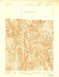
1937 Map of Mt Grace
USGS Topo · Published 1937About this map
Warwick serves as the central hub of this 1930s landscape, where a dense network of roads like Athol Road and Orange Road connects small highland settlements. The terrain is characterized by numerous family-named peaks and water bodies, including Hastings Pond and Sheomet Lake. Evidence of local industry and social organization is visible through features like Richards Mill Pond and the presence of a CCC Camp and Camp Warwick.
Find a feature on this map
86 named features on this map. Tap any name to fly to it.
Don’t see what you’re looking for? This feature index may not catch every label — zoom into the map to look around manually.
Map Details
Editions of this 1937 Mt Grace Map
This is the sole edition of this map. No revisions or reprints were ever made.
Other maps of this area

1887 · Warwick
USGS Topo · 1:62,500

1887 · Winchendon
USGS Topo · 1:62,500

1889 · Warwick
USGS Topo · 1:62,500

1890 · Winchendon
USGS Topo · 1:62,500

1894 · Winchendon
USGS Topo · 1:62,500

1894 · Warwick
USGS Topo · 1:62,500

1898 · Monadnock
USGS Topo · 1:62,500

1898 · Keene
USGS Topo · 1:62,500

1932 · Warwick
USGS Topo · 1:48,000

1932 · Winchendon
USGS Topo · 1:48,000