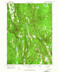
1961 Map of Mt Grace
USGS Topo · Published 1963About this map
Warwick and its surrounding uplands define this landscape at the intersection of Massachusetts and New Hampshire. The terrain is characterized by a series of north-south ridges and hills, such as Mt Grace and Tully Mtn, which frame the small settlements of North Orange and Tully to the south. Water management and forestry are central themes, with significant acreage dedicated to the Warwick State Forest and the Mt Grace State Forest. Numerous reservoirs and ponds, including Richards Reservoir and Sheomet Lake, dot the valleys between the peaks. The placement of South Cem and Gate Gates Cem provides critical points for genealogical research in this rural portion of Franklin County. Local landmarks like the Lookout Tower and Camp Warwick illustrate how the area served as both a working landscape and a site for conservation and recreation during the mid-twentieth century.
Find a feature on this map
73 named features on this map. Tap any name to fly to it.
Don’t see what you’re looking for? This feature index may not catch every label — zoom into the map to look around manually.
Map Details
Editions of this 1961 Mt Grace Map
This is the sole edition of this map. No revisions or reprints were ever made.
Other maps of this area

1887 · Warwick
USGS Topo · 1:62,500

1887 · Winchendon
USGS Topo · 1:62,500

1889 · Warwick
USGS Topo · 1:62,500

1890 · Winchendon
USGS Topo · 1:62,500

1894 · Winchendon
USGS Topo · 1:62,500

1894 · Warwick
USGS Topo · 1:62,500

1898 · Monadnock
USGS Topo · 1:62,500

1898 · Keene
USGS Topo · 1:62,500

1932 · Warwick
USGS Topo · 1:48,000

1932 · Winchendon
USGS Topo · 1:48,000