
1971 Map of Mt Toby
USGS Topo · Published 1978About this map
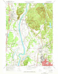
The Connecticut River winds through the heart of this Pioneer Valley landscape, defining the boundaries between Deerfield, Sunderland, and Whately. By the early 1970s, the southern portion of the map is dominated by the sprawling campus of the University of Massachusetts in Amherst, where landmarks like Alumni Stadium and Campus Pond are clearly visible. To the north, the terrain rises sharply at Mt Toby and the distinct peaks of North Sugarloaf Mtn and South Sugarloaf Mtn, which offered preserved recreational space even as the surrounding lowlands supported diverse utility. The map reveals a mix of academic expansion, active agriculture, and industry, from the State Fish Hatchery in Sunderland to the complex of cemeteries like Wildwood Cemetery and St Stanislaus Cem. Multiple rail lines, including the Central Vermont and Boston and Maine, trace the valley floor, connecting historic village centers such as North Hadley, Hatfield, and North Amherst.
Find a feature on this map
99 named features on this map. Tap any name to fly to it.
Don’t see what you’re looking for? This feature index may not catch every label — zoom into the map to look around manually.
Map Details
Editions of this 1971 Mt Toby Map
2 editions found
Other maps of this area

1885 · Northampton
USGS Topo · 1:62,500

1886 · Northampton
USGS Topo · 1:62,500

1887 · Warwick
USGS Topo · 1:62,500

1887 · Belchertown
USGS Topo · 1:62,500

1889 · Warwick
USGS Topo · 1:62,500

1890 · Belchertown
USGS Topo · 1:62,500

1890 · Greenfield
USGS Topo · 1:62,500

1891 · Northampton
USGS Topo · 1:62,500

1893 · Northampton
USGS Topo · 1:62,500

1893 · Belchertown
USGS Topo · 1:62,500