1982 Map of Mt. Washington
USGS Topo · Published 1983About this map
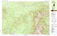
Mt Washington State Park and the high peaks of the Presidential Range dominate this early 1980s topographical record. The complex network of the Mount Washington Cog Railway is clearly visible, climbing from Marshfield Sta toward the summit, while the Mt Washington Auto Road winds its way up from the east. In the valleys, historic resort settlements like Bretton Woods and Fabyan sit along the Ammonoosuc River, shadowed by the Rosebrook Mtns. The map serves as a detailed directory of the era's backcountry infrastructure, locating high-altitude shelters like Madison Hut, The Perch Shelter, and Gray Knob Cabin. The inclusion of the Appalachian Trail crossing through the Great Gulf Wilderness highlights the region's long-standing role as a center for mountaineering and conservation within the White Mountain National Forest.
Find a feature on this map
137 named features on this map. Tap any name to fly to it.
Don’t see what you’re looking for? This feature index may not catch every label — zoom into the map to look around manually.
Map Details
Editions of this 1982 Mt. Washington Map
2 editions found

Other maps of this area

1893 · Mt. Washington
USGS Topo · 1:62,500

1893 · Gorham
USGS Topo · 1:62,500

1894 · North Conway
USGS Topo · 1:62,500

1895 · Crawford Notch
USGS Topo · 1:62,500

1896 · Mt. Washington
USGS Topo · 1:62,500

1896 · Crawford Notch
USGS Topo · 1:62,500

1896 · North Conway
USGS Topo · 1:62,500

1896 · Gorham
USGS Topo · 1:62,500

1900 · Whitefield
USGS Topo · 1:62,500

1929 · Franconia
USGS Topo · 1:62,500