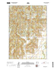
2020 Map of Muddy Valley
USGS Topo · Published 2020About this map
Mcminnville and its surrounding valleys characterize this landscape in the western Willamette Valley. The geography is defined by the drainage basins of Baker Cr and Muddy Cr, which flow through agricultural and orchard lands toward the South Yamhill River. Local heritage is preserved at sites like the South Yamhill Cem and Happy Valley Cem, while the modern economy is represented by Yamhill Orchards and the Deer Creek Airport. Prominent terrain features such as The Butte and Slide Mtn rise above the basin floor, offering a topographical contrast to the low-lying Muddy Valley and Gopher Valley. This survey provides a clear view of the rural-to-urban transition as the outskirts of the city reach toward Blue Heron Reservoir and the foothills of the Coast Range.
Find a feature on this map
73 named features on this map. Tap any name to fly to it.
Don’t see what you’re looking for? This feature index may not catch every label — zoom into the map to look around manually.
Map Details
Editions of this 2020 Muddy Valley Map
This is the sole edition of this map. No revisions or reprints were ever made.
Other maps of this area

1924 · Mc Minnville
USGS Topo · 1:48,000

1926 · Mc Minnville
USGS Topo · 1:62,500

1940 · McMinnville
USGS Topo · 1:62,500

1941 · Yamhill
USGS Topo · 1:62,500

1942 · Sheridan
USGS Topo · 1:62,500

1942 · Yamhill
USGS Topo · 1:62,500

1942 · Fairdale
USGS Topo · 1:62,500

1948 · Vancouver
USGS Topo · 1:250,000

1950 · Vancouver
USGS Topo · 1:250,000

1950 · Vancouver
USGS Topo · 1:250,000