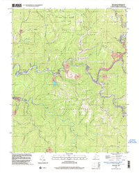
1996 Map of Mullens
USGS Topo · Published 2003About this map
The Guyandotte River carves a winding path through this corner of West Virginia's coal country, where the industrial landscape of the late 20th century is defined by steep ridges and narrow valley settlements. The operations of the Norfolk and Western RR are central to the region's geography, connecting coal towns like Itmann, Elmore, and Tralee along the riverbanks. Mining infrastructure is pervasive, with numerous Strip Mine sites, an Air Shaft Mine, and Tailings Ponds documented throughout the hills. In the northern section, Twin Falls Resort State Park occupies the highlands between Pretty Ridge and Cabin Creek Ridge, offering a public landscape that contrasts with the extractive industry nearby. Local history is anchored by community landmarks such as Conley Sch, Slab Fork Ch, and Bower Cem, which reflect the generations of families who settled along the hollows of Barkers Ridge and Pinnacle Creek.
Find a feature on this map
78 named features on this map. Tap any name to fly to it.
Don’t see what you’re looking for? This feature index may not catch every label — zoom into the map to look around manually.
Map Details
Editions of this 1996 Mullens Map
This is the sole edition of this map. No revisions or reprints were ever made.
Other maps of this area

1887 · Pocahontas
USGS Topo · 1:125,000

1891 · Tazewell
USGS Topo · 1:125,000

1891 · Pocahontas
USGS Topo · 1:125,000

1891 · Oceana
USGS Topo · 1:125,000

1891 · Raleigh
USGS Topo · 1:125,000

1893 · Oceana
USGS Topo · 1:125,000

1894 · Pocahontas
USGS Topo · 1:125,000

1895 · Tazewell
USGS Topo · 1:125,000

1895 · Pocahontas
USGS Topo · 1:125,000

1897 · Tazewell
USGS Topo · 1:125,000