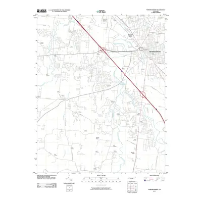
2010 Map of Murfreesboro
USGS Topo · Published 2010About this map
Stones River National Battlefield and the Military Park Brannons Redoubt anchor the historic landscape north of Murfreesboro, marking significant Civil War grounds along the West Fork Stones River. The area is densely populated with family and community burial sites, from the Old City Cemetery and Evergreen Cemetery in the city center to outlying locations like Washington Cemetery and Ridout Cemetery. This concentration of namesake cemeteries provides a valuable framework for genealogical research in Rutherford County.
Find a feature on this map
83 named features on this map. Tap any name to fly to it.
Don’t see what you’re looking for? This feature index may not catch every label — zoom into the map to look around manually.
Map Details
Editions of this 2010 Murfreesboro Map
This is the sole edition of this map. No revisions or reprints were ever made.
Other maps of this area

1916 · Murfreesboro
USGS Topo · 1:62,500

1936 · Webbs Jungle
USGS Topo · 1:24,000

1936 · Rover
USGS Topo · 1:24,000

1936 · Fosterville
USGS Topo · 1:24,000

1942 · Lebanon
USGS Topo · 1:100,000

1944 · Shelbyville
USGS Topo · 1:100,000
1949 · Rover
USGS Topo · 1:24,000
1949 · Webbs Jungle
USGS Topo · 1:24,000
1949 · Fosterville
USGS Topo · 1:24,000

1950 · Walterhill
USGS Topo · 1:24,000