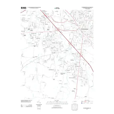
2013 Map of Murfreesboro
USGS Topo · Published 2013About this map
Stones River National Battlefield and the Military Park Brannons Redoubt anchor the northern reaches of this landscape, preserving the geography of one of the Civil War's most significant conflicts. The terrain is defined by the convergence of the W Fork Stones River and Middle Fork Stones River, with residential expansion pressing outward from Murfreesboro into established communities like Barfield and Crescent. Suburban developments such as Green Meadows, Southern Aire, and River Shores are woven through the karst topography of the Central Basin. Aviation history is represented by both the Murfreesboro Municipal Airport and the smaller Mc Donald Airport. Near the southern edge, the relief rises toward Barfield Knobs and Marshall Knobs, marking a transition from the river plains to more elevated ground. The map also captures local hydrological features like Sand Spring and Sterling Farmer Lake, illustrating the complex water network of Rutherford County.
Find a feature on this map
60 named features on this map. Tap any name to fly to it.
Don’t see what you’re looking for? This feature index may not catch every label — zoom into the map to look around manually.
Map Details
Editions of this 2013 Murfreesboro Map
This is the sole edition of this map. No revisions or reprints were ever made.
Other maps of this area

1916 · Murfreesboro
USGS Topo · 1:62,500

1936 · Webbs Jungle
USGS Topo · 1:24,000

1936 · Rover
USGS Topo · 1:24,000

1936 · Fosterville
USGS Topo · 1:24,000

1942 · Lebanon
USGS Topo · 1:100,000

1944 · Shelbyville
USGS Topo · 1:100,000
1949 · Rover
USGS Topo · 1:24,000
1949 · Webbs Jungle
USGS Topo · 1:24,000
1949 · Fosterville
USGS Topo · 1:24,000

1950 · Walterhill
USGS Topo · 1:24,000