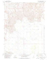
1980 Map of Murphys Well
USGS Topo · Published 1980About this map
Gabbs Valley dominates this 1980 survey, characterized by the expansive white expanse of the Alkali Flat. This arid landscape in Mineral County, Nevada, reflects the industrial and survival infrastructure necessary for desert life in the late twentieth century. Essential water sources like Murphys Well and various Water Tanks are spaced across the terrain, connected by a network of Jeep Trails and a significant underground Pipeline.
Find a feature on this map
12 named features on this map. Tap any name to fly to it.
Don’t see what you’re looking for? This feature index may not catch every label — zoom into the map to look around manually.
Map Details
Editions of this 1980 Murphys Well Map
This is the sole edition of this map. No revisions or reprints were ever made.
Other maps of this area

1908 · Carson Sink
USGS Topo · 1:250,000

1909 · Hawthorne
USGS Topo · 1:250,000

1910 · Carson Sink
USGS Topo · 1:250,000

1911 · Hawthorne
USGS Topo · 1:250,000

1915 · Hawthorne
USGS Topo · 1:250,000

1948 · Walker Lake
USGS Topo · 1:250,000

1957 · Walker Lake
USGS Topo · 1:250,000

1957 · Reno
USGS Topo · 1:250,000

1959 · Reno
USGS Topo · 1:250,000

1960 · Reno
USGS Topo · 1:250,000