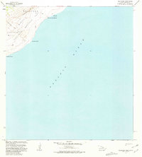
1981 Map of Naliikakani Point
USGS Topo · Published 1981About this map
Hawaii Volcanoes National Park dominates the northwest corner of this coastal quadrangle, where the land meets the Pacific Ocean along a stretch of the Kau District. The terrain is defined by its volcanic activity, notably featuring a wide Lava Flow that descends toward the sea, leaving a permanent mark on the topography. Coastal landmarks such as Naliikakani Point and Papalehau Point anchor the shoreline, while the interior is marked by geological features like Kukalauula and Na Puu o na Elemakule. A few scattered paths, including a Trail and the Pali, suggest the limited human movement through this coastal environment in the early 1980s. This survey, revised by the U.S. Geological Survey in cooperation with the Hawaii Dept. of Transportation, captures a landscape of cracks and volcanic deposits, emphasizing the dynamic natural forces at work in Kapapala and Kamoohii.
Find a feature on this map
16 named features on this map. Tap any name to fly to it.
Don’t see what you’re looking for? This feature index may not catch every label — zoom into the map to look around manually.
Map Details
Editions of this 1981 Naliikakani Point Map
This is the sole edition of this map. No revisions or reprints were ever made.
Other maps of this area

1921 · Kilauea
USGS Topo · 1:62,500

1922 · Puna
USGS Topo · 1:62,500

1923 · Pahala
USGS Topo · 1:62,500

1924 · Kilauea
USGS Topo · 1:62,500

1924 · Puna
USGS Topo · 1:62,500

1954 · Hawaii South
USGS Topo · 1:250,000

1959 · Hawaii South
USGS Topo · 1:250,000

1961 · Hawaii South
USGS Topo · 1:250,000

1962 · Hawaii South
USGS Topo · 1:250,000
1963 · Makaopuhi Crater
USGS Topo · 1:24,000