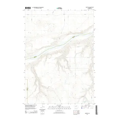
2014 Map of Naper SW
USGS Topo · Published 2014About this map
The Niobrara River carves a deep valley across this landscape, serving as the natural boundary between Holt County and Boyd County. This rural section of northern Nebraska is defined by its complex drainage network, where various watercourses like Otter Cr, W Br Clay Cr, and E Br Clay Cr flow toward the primary river valley. The terrain transitions from high plateaus down through steep-walled drainages such as Cedar Gulch. In the southeastern portion of the sheet, the MMK Reservoir Number 1 represents a significant modification to the drainage of Beaver Cr, likely serving agricultural needs in this ranching country. A grid of section-line roads, including Apple Rd and Bobcat Rd, provides access across the tablelands between the creek breaks.
Find a feature on this map
23 named features on this map. Tap any name to fly to it.
Don’t see what you’re looking for? This feature index may not catch every label — zoom into the map to look around manually.
Map Details
Editions of this 2014 Naper SW Map
This is the sole edition of this map. No revisions or reprints were ever made.
Other maps of this area

1950 · Mariaville
USGS Topo · 1:24,000

1951 · Naper
USGS Topo · 1:24,000

1951 · Dustin
USGS Topo · 1:24,000

1951 · Naper SW
USGS Topo · 1:24,000

1954 · Stuart NW
USGS Topo · 1:24,000

1954 · Newport NE
USGS Topo · 1:24,000

1954 · Stuart NE
USGS Topo · 1:24,000

1955 · O'Neill
USGS Topo · 1:250,000

1959 · O'Neill
USGS Topo · 1:250,000
1964 · Jamison
USGS Topo · 1:24,000