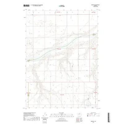
2017 Map of Naper SW
USGS Topo · Published 2017About this map
The Niobrara River carves a deep valley through this northern Nebraska landscape, serving as the primary geographic border between Boyd and Holt Counties. The river's path is defined by a network of drainage systems, including the northern Big Creek and Wright Creek, while the southern bank is fed by the intricate branches of Clay Creek and Otter Creek. The terrain reveals the transition from high prairie plateaus down to the river bottoms, with deep incisions like Cedar Gulch in the southeast. While the area remains largely rural and defined by large sections of land, human modification is evident in the MMK Reservoir Number 1 located near Beaver Creek. A grid of section roads, such as Copper Rd and Apple Rd, provides access to these remote ranching and farming lands near the Rock County line.
Find a feature on this map
30 named features on this map. Tap any name to fly to it.
Don’t see what you’re looking for? This feature index may not catch every label — zoom into the map to look around manually.
Map Details
Editions of this 2017 Naper SW Map
This is the sole edition of this map. No revisions or reprints were ever made.
Other maps of this area

1950 · Mariaville
USGS Topo · 1:24,000

1951 · Naper
USGS Topo · 1:24,000

1951 · Dustin
USGS Topo · 1:24,000

1951 · Naper SW
USGS Topo · 1:24,000

1954 · Stuart NW
USGS Topo · 1:24,000

1954 · Newport NE
USGS Topo · 1:24,000

1954 · Stuart NE
USGS Topo · 1:24,000

1955 · O'Neill
USGS Topo · 1:250,000

1959 · O'Neill
USGS Topo · 1:250,000
1964 · Jamison
USGS Topo · 1:24,000