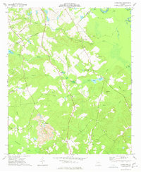
1973 Map of Napier Pond
USGS Topo · Published 1977About this map
Little Black Creek and its many tributaries, including Thompson Branch and Laurel Branch, define this wooded landscape along the border of Baldwin and Wilkinson Counties. The map documents a rural Georgia community in the early 1970s, characterized by numerous small family cemeteries and country churches. A massive Clay Pit and associated Tailings Pond indicate the importance of the local kaolin or clay industry, which physically reshaped the terrain near Lords Branch. These industrial excavations stand in contrast to the natural curves of the Oconee River and the scattered fishing spots such as Napier Pond, Goldens Pond, and White Lake. Genealogists will find significant value in the detailed placement of family burial grounds like the Price-Council-Carr Cem and Nunn-Wheeler Cem, as well as local landmarks like Peeler Chapel and Macedonia Ch.
Find a feature on this map
47 named features on this map. Tap any name to fly to it.
Don’t see what you’re looking for? This feature index may not catch every label — zoom into the map to look around manually.
Map Details
Editions of this 1973 Napier Pond Map
This is the sole edition of this map. No revisions or reprints were ever made.
Other maps of this area

1912 · Milledgeville
USGS Topo · 1:62,500

1916 · Irwinton
USGS Topo · 1:62,500

1920 · Irwinton
USGS Topo · 1:62,500

1953 · Athens
USGS Topo · 1:250,000

1956 · Gordon
USGS Topo · 1:62,500

1957 · Macon
USGS Topo · 1:250,000

1958 · Macon
USGS Topo · 1:250,000

1958 · Athens
USGS Topo · 1:250,000

1959 · Athens
USGS Topo · 1:250,000

1963 · Athens
USGS Topo · 1:250,000