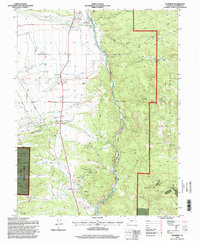
1994 Map of Nathrop
USGS Topo · Published 1998About this map
Arkansas River waters dominate this section of Chaffee County as they carve through Browns Canyon, a landscape defined by significant elevation changes and resource extraction. The map documents the rural settlements of Nathrop and Centerville during the mid-1990s, where small-scale agriculture is supported by the Pioneer Ditch and Kraft Ditch. Genealogists will find the Centerville Cem and another Cem near Nathrop, while the presence of the Railroad following the river corridor highlights the historic importance of this transportation artery.
Find a feature on this map
45 named features on this map. Tap any name to fly to it.
Don’t see what you’re looking for? This feature index may not catch every label — zoom into the map to look around manually.
Map Details
Editions of this 1994 Nathrop Map
This is the sole edition of this map. No revisions or reprints were ever made.
Other maps of this area

1954 · Pueblo
USGS Topo · 1:250,000

1955 · Buena Vista
USGS Topo · 1:62,500

1956 · Cameron Mountain
USGS Topo · 1:62,500

1956 · Poncha Springs
USGS Topo · 1:62,500

1956 · Montrose
USGS Topo · 1:250,000

1957 · Pueblo
USGS Topo · 1:250,000

1958 · Pueblo
USGS Topo · 1:250,000

1959 · Montrose
USGS Topo · 1:250,000

1959 · Antero Reservoir
USGS Topo · 1:62,500

1960 · Montrose
USGS Topo · 1:250,000