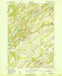
1951 Map of Natural Dam
USGS Topo · Published 1951About this map
The Oswegatchie River dominates this mid-century landscape, carving a winding path through the townships of Gouverneur, Macomb, and Rossie. The river’s importance to early industry and settlement is evident in the cluster of small communities and crossroads that line its banks, including Elmdale, Wegatchie, and the namesake Natural Dam. Along the southern boundary, the map captures a portion of the Pine Camp Military Reservation, providing a record of federal land use in the area during the early Cold War era.
Find a feature on this map
29 named features on this map. Tap any name to fly to it.
Don’t see what you’re looking for? This feature index may not catch every label — zoom into the map to look around manually.
Map Details
Editions of this 1951 Natural Dam Map
This is the sole edition of this map. No revisions or reprints were ever made.
Other maps of this area

1911 · Antwerp
USGS Topo · 1:62,500

1912 · Hammond
USGS Topo · 1:62,500

1913 · Lake Bonaparte
USGS Topo · 1:62,500

1915 · Gouverneur
USGS Topo · 1:62,500

1916 · Lake Bonaparte
USGS Topo · 1:62,500

1937 · Gouverneur
USGS Topo · 1:62,500

1944 · Hammond
USGS Topo · 1:62,500

1948 · Ogdensburg
USGS Topo · 1:250,000

1949 · Hammond
USGS Topo · 1:62,500

1949 · Antwerp
USGS Topo · 1:62,500