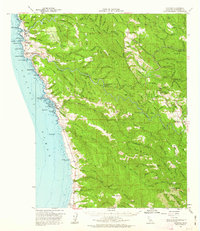
1961 Map of Navarro
USGS Topo · Published 1962About this map
Greenwood Ridge dominates the coastal topography of this 1961 survey, where the rugged Mendocino shoreline meets the deep redwood canyons of the Navarro River. The map documents a transitional era for the region's industry, showing the remnants of timber-era infrastructure like the Albion Railroad and Tramway Road alongside the establishment of Dimmick Memorial Grove State Park. Coastal settlements like Elk and Albion are shown in detail, while the map identifies former shipping points such as Whitesboro (Site) and Bridgeport Landing (Site) that had already faded into history.
Find a feature on this map
126 named features on this map. Tap any name to fly to it.
Don’t see what you’re looking for? This feature index may not catch every label — zoom into the map to look around manually.
Map Details
Editions of this 1961 Navarro Map
2 editions found
Other maps of this area

1920 · Glenblair
USGS Topo · 1:62,500

1920 · Fort Bragg
USGS Topo · 1:62,500

1922 · Willits
USGS Topo · 1:62,500

1942 · Willits
USGS Topo · 1:62,500

1943 · Point Arena
USGS Topo · 1:62,500

1943 · Glenblair
USGS Topo · 1:62,500

1943 · Fort Bragg
USGS Topo · 1:62,500

1943 · Albion
USGS Topo · 1:62,500

1943 · Boonville
USGS Topo · 1:62,500

1943 · Navarro
USGS Topo · 1:62,500