
Loading...
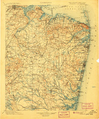
Loading map...1902 Map of Navesink
USGS Topo · Published 1902About this map
The Raritan River and its industrial tributaries anchor this coastal New Jersey landscape at the opening of the twentieth century. From the established hub of New Brunswick to the defensive installations at Fort Hancock, the map reveals a region defined by its rail-and-water transport networks. The Pennsylvania R. R. and Central R. R. of New Jersey crisscross the interior, connecting smaller settlements like Old Bridge, Spotswood, and Jamesburg.
Find a feature on this map
274 named features on this map. Tap any name to fly to it.
Don’t see what you’re looking for? This feature index may not catch every label — zoom into the map to look around manually.
Map Details
Date Portrayed1902
Date Published1902
PublisherU.S. Geological Survey
Map TypeTopographic
Scale1:125000
Physical Dimensions16.4 x 19.9 inches
Editions of this 1902 Navesink Map
3 editions found

Historical Maps of Colonial Oaks Through Time
1 maps found
Featured Locations
Source Details
SourceU.S. Geological Survey
CopyrightPublic Domain