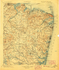
1902 Map of Navesink
USGS Topo · Published 1907About this map
Sandy Hook and the northern shore of Monmouth County dominate this coastal survey, where the Raritan River meets the Lower Bay near Sayreville. Inland, the landscape is defined by the early industrial and agricultural corridors of the Pennsylvania R.R. and Central R.R. of N.J., connecting established settlements like New Brunswick, Milltown, and Old Bridge. This era shows a network of water-powered industry at Weston Mills, Wescott Mills, and Bergen Mills, while the State Reform School near Jamesburg stands as a prominent institutional landmark. The coastal defenses at Fort Hancock and the numerous Life Saving Stations (L.S.S.) along the Atlantic indicate the maritime importance of the Navesink highlands and the entrance to New York Harbor. The southern reaches transition into the pine barrens, where the headwaters of the Toms River and Ridgeway Branch begin to snake through a less densely settled interior.
Find a feature on this map
296 named features on this map. Tap any name to fly to it.
Don’t see what you’re looking for? This feature index may not catch every label — zoom into the map to look around manually.
Map Details
Editions of this 1902 Navesink Map
3 editions found

Other maps of this area

1884 · Whitings
USGS Topo · 1:62,500

1888 · Plainfield
USGS Topo · 1:62,500

1888 · Bordentown
USGS Topo · 1:62,500

1888 · Pemberton
USGS Topo · 1:62,500

1888 · Barnegat
USGS Topo · 1:62,500

1888 · New Brunswick
USGS Topo · 1:62,500

1888 · Princeton
USGS Topo · 1:62,500

1888 · Asbury Park
USGS Topo · 1:62,500

1888 · Cassville
USGS Topo · 1:62,500

1888 · Sandy Hook
USGS Topo · 1:62,500