
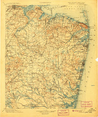
1902 Map of Navesink
USGS Topo · Published 1912About this map
Sandy Hook and the northern coastline of Monmouth Co. define this coastal landscape at the turn of the century, showing a region where maritime defense and burgeoning resort culture coexist. To the north, Fort Hancock guards the entrance to Lower Bay, while further south, the Victorian-era shore communities of Asbury Park, Sea Girt, and Point Pleasant are already well-established along the New York And Long Branch Railroad. The map reveals an intricate network of waterways, from the broad Raritan River and Navesink River to the smaller estuaries like Shark River and the Shrewsbury River, which facilitated both transport and local industry.
Find a feature on this map
58 named features on this map. Tap any name to fly to it.
Don’t see what you’re looking for? This feature index may not catch every label — zoom into the map to look around manually.
Map Details
Editions of this 1902 Navesink Map
3 editions found

Other maps of this area

1884 · Whitings
USGS Topo · 1:62,500

1888 · Plainfield
USGS Topo · 1:62,500

1888 · Bordentown
USGS Topo · 1:62,500

1888 · Pemberton
USGS Topo · 1:62,500

1888 · Barnegat
USGS Topo · 1:62,500

1888 · New Brunswick
USGS Topo · 1:62,500

1888 · Princeton
USGS Topo · 1:62,500

1888 · Asbury Park
USGS Topo · 1:62,500

1888 · Cassville
USGS Topo · 1:62,500

1888 · Sandy Hook
USGS Topo · 1:62,500