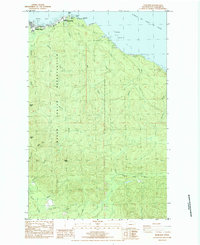
1984 Map of Neah Bay
USGS Topo · Published 1984About this map
Neah Bay serves as the focal point of this coastal landscape, situated within the Makah Indian Reservation at the northwestern tip of the Olympic Peninsula. The shoreline of the Strait of Juan de Fuca is marked by distinctive geological formations like Seal Rock and Sail Rock, while the town itself contains essential facilities including the Neah Bay Coast Guard Station, a Makah BIA Agency, and a Substation.
Find a feature on this map
37 named features on this map. Tap any name to fly to it.
Don’t see what you’re looking for? This feature index may not catch every label — zoom into the map to look around manually.
Map Details
Editions of this 1984 Neah Bay Map
This is the sole edition of this map. No revisions or reprints were ever made.
Other maps of this area

1935 · Clallam
USGS Topo · 1:62,500

1935 · Ozette Lake
USGS Topo · 1:62,500

1935 · Lake Pleasant
USGS Topo · 1:62,500

1938 · Cape Flattery
USGS Topo · 1:62,500

1942 · Clallam
USGS Topo · 1:62,500

1942 · Ozette Lake
USGS Topo · 1:62,500

1942 · Lake Pleasant
USGS Topo · 1:62,500

1953 · Cape Flattery
USGS Topo · 1:250,000

1956 · Ozette Lake
USGS Topo · 1:62,500

1957 · Lake Pleasant
USGS Topo · 1:62,500