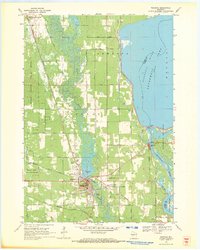
1969 Map of Necedah
USGS Topo · Published 1971About this map
Necedah occupies a transition point between the wetlands of the Necedah National Wildlife Refuge and the engineered waters of Petenwell Lake. In the late 1960s, the village is centered at the junction of the Yellow River and the Chicago and North Western and Chicago Milwaukee St Paul and Pacific railroads. The topography is dominated by the prominent Necedah Bluff, overlooking the town and the Queen of the Holy Rosary Shrine.
Find a feature on this map
40 named features on this map. Tap any name to fly to it.
Don’t see what you’re looking for? This feature index may not catch every label — zoom into the map to look around manually.
Map Details
Editions of this 1969 Necedah Map
This is the sole edition of this map. No revisions or reprints were ever made.
Other maps of this area

1921 · Mauston
USGS Topo · 1:62,500

1953 · Eau Claire
USGS Topo · 1:250,000

1955 · Green Bay
USGS Topo · 1:250,000

1957 · Madison
USGS Topo · 1:250,000

1958 · Eau Claire
USGS Topo · 1:250,000

1958 · Arkdale
USGS Topo · 1:48,000

1958 · Necedah
USGS Topo · 1:48,000

1958 · La Crosse
USGS Topo · 1:250,000

1960 · Madison
USGS Topo · 1:250,000

1961 · La Crosse
USGS Topo · 1:250,000