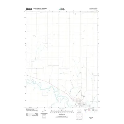
2011 Map of Neligh
USGS Topo · Published 2011About this map
Neligh serves as the focal point of this Antelope County landscape, situated where Antelope Creek and Hail Creek converge with the winding Elkhorn River. The map illustrates the town's organized grid south of the river, featuring the Neligh Post Office and the riverside Laurel Hill Cemetery. This 2011 survey documents a mix of modern infrastructure and long-standing transport corridors, including the Cowboy Trl, a recreational conversion of a historic rail line that cuts diagonally across the river valley. The surrounding terrain is defined by a rigid section-line road network, such as 857th Rd and 528th Ave, which delineates the vast agricultural tracts typical of the Nebraska plains. Smaller waterways like Belmer Creek further articulate the drainage patterns of this prairie region, showing how the local topography influenced the placement of original homestead roads.
Find a feature on this map
24 named features on this map. Tap any name to fly to it.
Don’t see what you’re looking for? This feature index may not catch every label — zoom into the map to look around manually.
Map Details
Editions of this 2011 Neligh Map
This is the sole edition of this map. No revisions or reprints were ever made.
Other maps of this area

1955 · Sioux City
USGS Topo · 1:250,000

1955 · O'Neill
USGS Topo · 1:250,000

1958 · Sioux City
USGS Topo · 1:250,000

1959 · O'Neill
USGS Topo · 1:250,000

1959 · Sioux City
USGS Topo · 1:250,000

1963 · Neligh
USGS Topo · 1:24,000

1963 · Neligh SE
USGS Topo · 1:24,000
1963 · Oakdale
USGS Topo · 1:24,000

1963 · Brunswick
USGS Topo · 1:24,000

1963 · Neligh SW
USGS Topo · 1:24,000