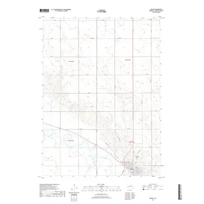
2017 Map of Neligh
USGS Topo · Published 2017About this map
Neligh serves as the focal point of this Antelope County landscape, situated where the Elkhorn River meets the local drainage network of Hail Cr and Antelope Cr. The town's grid is well-defined by streets such as W 11th St and E 2nd St, reflecting a settled agricultural hub. To the north of the main residential center, Laurel Hill Cem is positioned along Cemetery Rd, providing a specific point of interest for those researching local family histories. The surrounding terrain is primarily characterized by a systematic grid of section roads, including 857th Rd and Pierce Rd, which cross the rolling landscape and seasonal watercourses like Willow Cr and Beemer Cr. The relationship between the river valley and the elevated plains is clearly visible, showing how the regional infrastructure follows the natural topography of the Elkhorn basin.
Find a feature on this map
40 named features on this map. Tap any name to fly to it.
Don’t see what you’re looking for? This feature index may not catch every label — zoom into the map to look around manually.
Map Details
Editions of this 2017 Neligh Map
This is the sole edition of this map. No revisions or reprints were ever made.
Other maps of this area

1955 · Sioux City
USGS Topo · 1:250,000

1955 · O'Neill
USGS Topo · 1:250,000

1958 · Sioux City
USGS Topo · 1:250,000

1959 · O'Neill
USGS Topo · 1:250,000

1959 · Sioux City
USGS Topo · 1:250,000

1963 · Neligh
USGS Topo · 1:24,000

1963 · Neligh SE
USGS Topo · 1:24,000
1963 · Oakdale
USGS Topo · 1:24,000

1963 · Brunswick
USGS Topo · 1:24,000

1963 · Neligh SW
USGS Topo · 1:24,000