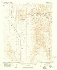
1958 Map of Nelson
USGS Topo · Published 1959About this map
Nelson and its surrounding mining districts dominate this 1950s landscape, where dozens of hard-rock claims are etched into the Eldorado Mountains. The map reveals a dense concentration of historical mining activity in Eldorado Canyon, featuring legendary sites like the Techatticup Mine and the Wall Street Mine. Beyond the industrial activity, the survey notes cultural markers such as Petroglyphs in Keyhole Canyon and a lone Cemetery near the townsite. The rugged topography transitions from the high Ireteba Peaks down to the eastern boundary at the Lake Mead National Recreation Area. This document records a period when small-scale operations like Capital Camp still occupied the desert landscape, providing a primary source for locating early 20th-century Nevada mining claims and family-named landmarks.
Find a feature on this map
32 named features on this map. Tap any name to fly to it.
Don’t see what you’re looking for? This feature index may not catch every label — zoom into the map to look around manually.
Map Details
Editions of this 1958 Nelson Map
2 editions found
Other maps of this area

1886 · Camp Mohave
USGS Topo · 1:250,000

1892 · Camp Mohave
USGS Topo · 1:250,000

1910 · Ivanpah
USGS Topo · 1:250,000

1912 · Ivanpah
USGS Topo · 1:250,000

1926 · Nelson
USGS Topo · 1:96,000

1926 · Mohave City
USGS Topo · 1:96,000

1942 · Camp Mohave
USGS Topo · 1:250,000

1942 · Ivanpah
USGS Topo · 1:250,000

1947 · Kingman
USGS Topo · 1:250,000

1948 · Kingman
USGS Topo · 1:250,000