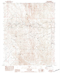
1984 Map of Nelson
USGS Topo · Published 1984About this map
The Nelson mining district dominates this arid landscape within the Eldorado Mountains, revealing a complex network of tunnels and shafts that defined the region's economy during the mid-1980s. Centered around Eldorado Canyon, the map identifies dozens of specific mining operations, including the Techatticup Mine and Wall Street Mine. The terrain is characterized by a series of dry washes such as Techatticup Wash and Morning Star Wash that cut through the steep topography. To the east, the boundary of the Lake Mead National Recreation Area introduces a shift from industrial mining activity to protected federal land. Notable landmarks like Knob Hill and the Ireteba Peaks serve as prominent navigational points amidst the dense concentration of lode claims, while remote outposts like Capitol Camp and the Oro Plata Mine illustrate the reach of prospecting into the furthest reaches of the range.
Find a feature on this map
45 named features on this map. Tap any name to fly to it.
Don’t see what you’re looking for? This feature index may not catch every label — zoom into the map to look around manually.
Map Details
Editions of this 1984 Nelson Map
This is the sole edition of this map. No revisions or reprints were ever made.
Other maps of this area

1886 · Camp Mohave
USGS Topo · 1:250,000

1892 · Camp Mohave
USGS Topo · 1:250,000

1926 · Nelson
USGS Topo · 1:96,000

1942 · Camp Mohave
USGS Topo · 1:250,000

1947 · Kingman
USGS Topo · 1:250,000

1948 · Kingman
USGS Topo · 1:250,000

1954 · Kingman
USGS Topo · 1:250,000

1955 · Kingman
USGS Topo · 1:250,000

1958 · Kingman
USGS Topo · 1:250,000
1958 · Boulder City SW
USGS Topo · 1:24,000