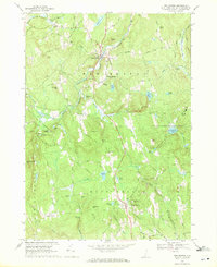
1968 Map of New Boston
USGS Topo · Published 1971About this map
New Boston serves as the focal point of this rural Hillsborough County landscape, situated at the confluence of the Middle Branch and South Branch Piscataquog River. The terrain is defined by a series of prominent drumlins and heights, including Meetinghouse Hill, Hooper Hill, and the massive Joe English Hill, which dominates the eastern portion of the quadrangle. This area is notably occupied by a large US Military Reservation, creating a distinct boundary between the town's agricultural and residential development and restricted federal lands.
Find a feature on this map
94 named features on this map. Tap any name to fly to it.
Don’t see what you’re looking for? This feature index may not catch every label — zoom into the map to look around manually.
Map Details
Editions of this 1968 New Boston Map
Other maps of this area

1900 · Peterboro
USGS Topo · 1:62,500

1906 · Milford
USGS Topo · 1:62,500

1926 · Hillsboro
USGS Topo · 1:62,500

1927 · Concord
USGS Topo · 1:62,500

1929 · Hillsboro
USGS Topo · 1:62,500

1943 · Fitchburg
USGS Topo · 1:125,000

1948 · Boston
USGS Topo · 1:250,000

1949 · Portland
USGS Topo · 1:250,000

1949 · Concord
USGS Topo · 1:62,500
1953 · Peterborough
USGS Topo · 1:62,500