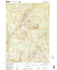
1995 Map of New Boston
USGS Topo · Published 1999About this map
The New Hampshire Satellite Tracking Station dominates the eastern ridge lines of this Hillsborough County landscape, situated near Joe English Hill and Roby Hill. The township of New Boston sits at the confluence of the South Branch Piscataquog River and the main Piscataquog River, showcasing a classic New England river-valley settlement pattern. To the south, the village of Mont Vernon anchors the highlands above Stearns Pond and Jew Pond.
Find a feature on this map
60 named features on this map. Tap any name to fly to it.
Don’t see what you’re looking for? This feature index may not catch every label — zoom into the map to look around manually.
Map Details
Editions of this 1995 New Boston Map
This is the sole edition of this map. No revisions or reprints were ever made.
Other maps of this area

1900 · Peterboro
USGS Topo · 1:62,500

1906 · Milford
USGS Topo · 1:62,500

1926 · Hillsboro
USGS Topo · 1:62,500

1927 · Concord
USGS Topo · 1:62,500

1929 · Hillsboro
USGS Topo · 1:62,500

1943 · Fitchburg
USGS Topo · 1:125,000

1948 · Boston
USGS Topo · 1:250,000

1949 · Portland
USGS Topo · 1:250,000

1949 · Concord
USGS Topo · 1:62,500
1953 · Peterborough
USGS Topo · 1:62,500