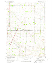
1972 Map of New Effington NE
USGS Topo · Published 1974About this map
The North Dakota South Dakota Boundary bisects this landscape, dividing the northern townships of Greendale and La Mars from Victor to the south. The terrain is defined by the sweeping course of Big Slough, which meanders through the southern half of the quadrangle. For genealogists and local historians, the map is remarkably well-documented with several rural burial sites, including Old Brandvold Cem, Brandvold Ch Cem, and St Nicholas Cem. These sites, along with Tyson Cem to the northwest, offer a precise look at early settlement patterns near the Sisseton Indian Reservation border. Transportation is anchored by the Soo Line railroad, which runs across the southern townships, marking the infrastructure that once supported these prairie agricultural communities in the early 1970s.
Find a feature on this map
15 named features on this map. Tap any name to fly to it.
Don’t see what you’re looking for? This feature index may not catch every label — zoom into the map to look around manually.
Map Details
Editions of this 1972 New Effington NE Map
This is the sole edition of this map. No revisions or reprints were ever made.
Other maps of this area

1904 · Wahpeton
USGS Topo · 1:125,000

1915 · White Rock
USGS Topo · 1:62,500

1917 · New Effington
USGS Topo · 1:62,500

1918 · White Rock
USGS Topo · 1:62,500

1953 · Milbank
USGS Topo · 1:250,000

1953 · Fargo
USGS Topo · 1:250,000

1956 · Fargo
USGS Topo · 1:250,000

1958 · Milbank
USGS Topo · 1:250,000

1964 · Hankinson
USGS Topo · 1:24,000

1964 · Hankinson SE
USGS Topo · 1:24,000
Featured Places
- Greendale Township, ND
- Lake Traverse District, SD
- LaMars Township, ND
- Heipa District
- Richland County, ND