
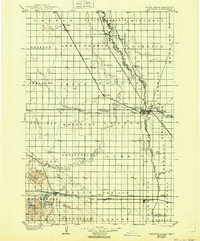
1904 Map of Wahpeton
USGS Topo · Published 1904About this map
Red River of the North serves as the focal point for this early 20th-century borderlands survey, marking the serpentine boundary between North Dakota and Minnesota. At the center of the region's rail-driven economy are the twin settlements of Wahpeton and Breckenridge, where the Otter Tail River converges with the Red River. This period of rapid agricultural expansion is evidenced by the dense grid of townships and the convergence of five major rail lines, including the Great Northern and the Northern Pacific, which connected emerging grain-elevator towns like Hankinson, Abercrombie, and Fairmount to larger markets.
Find a feature on this map
74 named features on this map. Tap any name to fly to it.
Don’t see what you’re looking for? This feature index may not catch every label — zoom into the map to look around manually.
Map Details
Editions of this 1904 Wahpeton Map
2 editions found
Other maps of this area

1895 · Fargo
USGS Topo · 1:125,000

1895 · Casselton
USGS Topo · 1:125,000

1897 · Fargo
USGS Topo · 1:125,000

1897 · Casselton
USGS Topo · 1:125,000

1907 · Wyndmere
USGS Topo · 1:125,000

1915 · White Rock
USGS Topo · 1:62,500

1917 · New Effington
USGS Topo · 1:62,500

1918 · White Rock
USGS Topo · 1:62,500
1919 · Rothsay
USGS Topo · 1:62,500
1919 · Barnesville
USGS Topo · 1:62,500