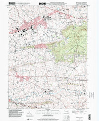
1999 Map of New Holland
USGS Topo · Published 2001About this map
The agricultural and industrial character of Lancaster County is prominent here, centered on the borough of New Holland. This 1999 update of 1951 topographic data reveals a landscape where traditional farmsteads and rural schools like Western Sch and Mussers Sch coexist with modern infrastructure, including a large Sewage Disposal Plant and a Microwave Tower. The map traces the varied terrain from the heights of Welsh Mountain down to the lowlands shaped by Pequea Creek and its many tributaries such as Groff Creek and Muddy Run.
Find a feature on this map
63 named features on this map. Tap any name to fly to it.
Don’t see what you’re looking for? This feature index may not catch every label — zoom into the map to look around manually.
Map Details
Editions of this 1999 New Holland Map
This is the sole edition of this map. No revisions or reprints were ever made.
Other maps of this area

1904 · Coatesville
USGS Topo · 1:62,500

1905 · Honey Brook
USGS Topo · 1:62,500

1906 · Coatesville
USGS Topo · 1:62,500

1906 · New Holland
USGS Topo · 1:62,500

1907 · Honeybrook
USGS Topo · 1:62,500

1908 · New Holland
USGS Topo · 1:62,500

1912 · Quarryville
USGS Topo · 1:62,500

1918 · Coatesville
USGS Topo · 1:62,500

1941 · Honeybrook
USGS Topo · 1:62,500

1941 · New Holland
USGS Topo · 1:62,500
Featured Places
- East Earl Township, PA
- New Holland, PA
- Paradise Township, PA
- Blue Ball, East Earl Township
- Leacock Township, PA