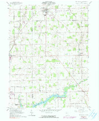
1961 Map of New Knoxville
USGS Topo · Published 1991About this map
Lake Loramie and the surrounding agricultural landscapes of Auglaize and Shelby Counties are documented in this 1961 record of west-central Ohio. The map captures a corridor of German-heritage settlements, including New Knoxville, New Bremen, and Minster, connected by a grid of rural roads like Lock Two Road and Amsterdam Road. The southern portion of the sheet is dominated by the Loramie State Lake Park and its various recreation points, such as Lehinkuhl Landing. Local genealogy is well-served by several clearly marked family and community burial grounds, including Pilger Ruhe Cem, Willow Grove Cem, and Schwaberow Cem. Scattered industry is visible through labels for a Gravel Pit and several Oil Well sites, reflecting the region's diverse economic activities during the mid-20th century.
Find a feature on this map
42 named features on this map. Tap any name to fly to it.
Don’t see what you’re looking for? This feature index may not catch every label — zoom into the map to look around manually.
Map Details
Editions of this 1961 New Knoxville Map
Other maps of this area

1906 · Lima
USGS Topo · 1:62,500

1909 · Loramie
USGS Topo · 1:62,500

1911 · Loramie
USGS Topo · 1:62,500

1911 · Spencerville
USGS Topo · 1:62,500

1913 · Sidney
USGS Topo · 1:62,500

1944 · Sidney
USGS Topo · 1:62,500

1944 · Loramie
USGS Topo · 1:62,500

1944 · Spencerville
USGS Topo · 1:62,500

1953 · Muncie
USGS Topo · 1:250,000

1956 · Muncie
USGS Topo · 1:250,000