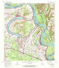
1963 Map of New Roads
USGS Topo · Published 1971About this map
The Mississippi River dominates this mid-century landscape, framing the oxbow curve of False River and the fertile alluvial plains of Pointe Coupee Parish. The town of New Roads serves as a central hub, surrounded by a dense network of plantation-era settlements and landings such as Parlange, Hermitage, and Chenal. The complex hydrology of the delta is evident in the numerous cutoffs and bayous, including False River Cutoff 1722 and Grosse Tete Bayou, while the Texas and Pacific and Missouri Pacific railroads provide critical transportation links through the bottomlands. Genealogists will find a wealth of specific local landmarks, from the Port Hudson National Cemetery to small community anchors like St Alma School and numerous rural churches including Mt Pilgrim Church and Cemetery. The map also captures several noted landings such as Dugan Landing and Red Store Landing, reflecting the area's deep reliance on river commerce.
Find a feature on this map
138 named features on this map. Tap any name to fly to it.
Don’t see what you’re looking for? This feature index may not catch every label — zoom into the map to look around manually.
Map Details
Editions of this 1963 New Roads Map
2 editions found
Other maps of this area

1906 · Bayou Sara
USGS Topo · 1:125,000

1908 · Baton Rouge
USGS Topo · 1:62,500

1935 · Osca Bayou
USGS Topo · 1:62,500

1939 · St. Francisville
USGS Topo · 1:62,500

1939 · Zachary
USGS Topo · 1:62,500

1939 · Baton Rouge
USGS Topo · 1:62,500

1939 · Fordoche
USGS Topo · 1:62,500

1940 · Grosse Tete
USGS Topo · 1:62,500

1941 · Batchelor
USGS Topo · 1:62,500

1945 · Jackson
USGS Topo · 1:31,680