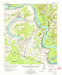
1965 Map of New Roads
USGS Topo · Published 1965About this map
False River defines the landscape of central Pointe Coupee Parish, an oxbow lake cut off from the main Mississippi River channel. This mid-1960s survey documents a complex network of landings and revetments like Red Store Landing Revetment and Arrow Bend Revetment, built to stabilize the shifting riverbanks. The settlement of New Roads serves as the local hub, connected by the Texas and Pacific and Missouri Pacific railroads to outlying agricultural communities such as Erwinville, Lakeland, and Torbert P O. Along the river's eastern banks, the Port Hudson National Cem stands near the site of major Civil War engagements, marking a significant transition into East Baton Rouge Parish. The interior is characterized by expansive lowlands known as The Island, where a dense web of bayous including Stumpy Bayou and Grand Bayou weave through reclaimed land and small church-centered hamlets like St Ambrose Ch and St Marks Ch.
Find a feature on this map
143 named features on this map. Tap any name to fly to it.
Don’t see what you’re looking for? This feature index may not catch every label — zoom into the map to look around manually.
Map Details
Editions of this 1965 New Roads Map
This is the sole edition of this map. No revisions or reprints were ever made.
Other maps of this area

1906 · Bayou Sara
USGS Topo · 1:125,000

1908 · Baton Rouge
USGS Topo · 1:62,500

1935 · Osca Bayou
USGS Topo · 1:62,500

1939 · St. Francisville
USGS Topo · 1:62,500

1939 · Zachary
USGS Topo · 1:62,500

1939 · Baton Rouge
USGS Topo · 1:62,500

1939 · Fordoche
USGS Topo · 1:62,500

1940 · Grosse Tete
USGS Topo · 1:62,500

1941 · Batchelor
USGS Topo · 1:62,500

1945 · Jackson
USGS Topo · 1:31,680