2024 Map of New Smyrna Beach
USGS Topo · Published 2024About this map
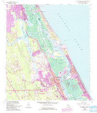
New Smyrna Beach and its surrounding coastal communities are anchored by the complex hydrology of the Halifax River and Indian River North. This survey details a landscape defined by saltwater estuaries and historic transit routes, where the Intracoastal Waterway cuts through Bass Flats and Sheephead Cut. Local heritage is preserved in small burial grounds such as the Pacetti Family Cem and the Glencoe-Geiger Cem, while the Ponce Inlet Grave Site offers a specific point of historical interest near the Ponce de Leon Inlet. The map traces the growth of coastal developments from Wilbur-by-the-Sea south toward Edgewater, showing the layout of Mission City and Isleboro. From the aviation hub at New Smyrna Beach Municipal Airport to the secluded reaches of Mosquito Lagoon and Browns Bay, the sheet documents the modern infrastructure and natural waterways of this Volusia County corridor.
Find a feature on this map
112 named features on this map. Tap any name to fly to it.
Don’t see what you’re looking for? This feature index may not catch every label — zoom into the map to look around manually.
Map Details
Editions of this 2024 New Smyrna Beach Map
This is the sole edition of this map. No revisions or reprints were ever made.
Historical Maps of Allandale Through Time
3 maps found