
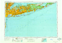
1954 Map of New York
USGS Topo · Published 1954About this map
Long Island stretches eastward into the Atlantic Ocean in this mid-century portrait of suburban expansion and military infrastructure. The post-war housing boom is evident in the dense residential grids of Levittown, Hicksville, and Brentwood, while the older coastal identities of Sag Harbor and Montauk remain distinct at the eastern forks. The landscape is interconnected by the expanding reaches of the Sunrise Highway and the Long Island Rail Road, supporting a commute-heavy economy centered on New York City. Significant institutional and military footprints are visible across the island, including the Brookhaven National Laboratory and aviation hubs like Mitchel Afb and Grumman Airfield. Along the southern shore, the long barrier of Fire Island protects the Great South Bay, highlighting the maritime geography that has defined the region from the Statue of Liberty to Orient Point.
Find a feature on this map
82 named features on this map. Tap any name to fly to it.
Don’t see what you’re looking for? This feature index may not catch every label — zoom into the map to look around manually.
Map Details
Editions of this 1954 New York Map
2 editions found
Other maps of this area

1888 · Barnegat
USGS Topo · 1:62,500

1888 · Asbury Park
USGS Topo · 1:62,500

1888 · Paterson
USGS Topo · 1:62,500

1888 · Sandy Hook
USGS Topo · 1:62,500

1889 · Brooklyn
USGS Topo · 1:62,500

1891 · Ramapo
USGS Topo · 1:62,500

1891 · Brooklyn
USGS Topo · 1:62,500

1891 · Harlem
USGS Topo · 1:62,500

1891 · Bridgeport
USGS Topo · 1:62,500

1892 · Stamford
USGS Topo · 1:62,500