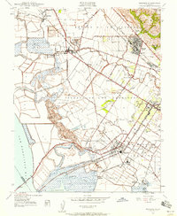
1947 Map of Newark
USGS Topo · Published 1958About this map
Newark and the surrounding East Bay communities of Alvarado and Decoto anchor this 1947 landscape, where industrial salt production meets fertile agricultural flats. The map documents a critical infrastructure network, including the Hetch Hetchy Aqueduct and Spring Valley Aqueduct cutting across the marshlands near San Francisco Bay. Along the shoreline, specialized facilities like the Chlorine Works, Salt Refinery, and Sugar Refinery illustrate the mid-century industrial economy, while the Southern Pacific Railroad provides the essential transport links for these goods. Inland, family-named landmarks and old landing sites such as Jarvis Landing and Mowry Landing mark the historical connection between the land and the bay. The transition from the alluvial plain of Arroyo De La Alameda to the elevations of the Coyote Hills and Red Hill provides a distinct topographic contrast in an area that would soon undergo rapid suburban transformation.
Find a feature on this map
59 named features on this map. Tap any name to fly to it.
Don’t see what you’re looking for? This feature index may not catch every label — zoom into the map to look around manually.
Map Details
Editions of this 1947 Newark Map
This is the sole edition of this map. No revisions or reprints were ever made.
Other maps of this area

1889 · San Jose
USGS Topo · 1:62,500

1897 · San Jose
USGS Topo · 1:62,500

1897 · Palo Alto
USGS Topo · 1:62,500

1899 · San Jose
USGS Topo · 1:62,500

1899 · Palo Alto
USGS Topo · 1:62,500

1899 · Haywards
USGS Topo · 1:62,500

1902 · Santa Cruz
USGS Topo · 1:125,000

1906 · Pleasanton
USGS Topo · 1:62,500

1915 · Haywards
USGS Topo · 1:62,500

1941 · Pleasanton
USGS Topo · 1:62,500