
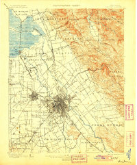
1899 Map of San Jose
USGS Topo · Published 1899About this map
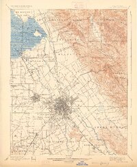
The San Jose area at the end of the 19th century is characterized by a sprawling grid of city streets transitioning into the vast agricultural tracts and ranchos of the Santa Clara Valley. The landscape is defined by the complex drainage of the Coyote River and Guadalupe River, flowing north toward the salt marshes and sloughs of Alviso. Regional infrastructure is prominently represented by the Southern Pacific railroad lines and early landmarks such as the Santa Clara Co. Alms House and the County Infirmary. Beyond the urban core, the map detail encompasses distinct local settlements like Milpitas, Berryessa, and Evergreen, as well as the transition from the valley floor to the elevations of the Los Buellis Hills. The presence of the Asylum at Agnew and College Park near the city center provides a glimpse into the institutional and educational foundations of the region during this era of growth.
Find a feature on this map
56 named features on this map. Tap any name to fly to it.
Don’t see what you’re looking for? This feature index may not catch every label — zoom into the map to look around manually.
Map Details
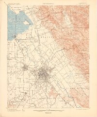
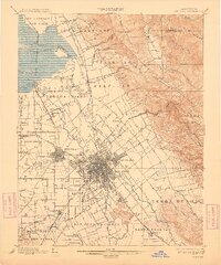
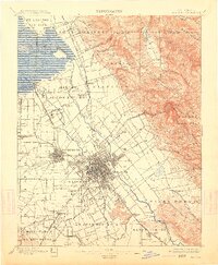
Editions of this 1899 San Jose Map
6 editions found
Other maps of this area

1889 · San Jose
USGS Topo · 1:62,500

1897 · San Jose
USGS Topo · 1:62,500

1897 · Mt. Hamilton
USGS Topo · 1:62,500

1897 · Palo Alto
USGS Topo · 1:62,500

1899 · Palo Alto
USGS Topo · 1:62,500

1899 · Haywards
USGS Topo · 1:62,500

1902 · Santa Cruz
USGS Topo · 1:125,000

1906 · Pleasanton
USGS Topo · 1:62,500

1907 · Tesla
USGS Topo · 1:62,500

1915 · Haywards
USGS Topo · 1:62,500