Loading...
Loading map...1983 Map of Ngermetengel
USGS Topo · Published 1984About this map
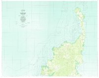
Ngermetengel and the northern coastline of Babeldaob island are captured here following field checks in 1980. This detailed study of the Republic of Palau reveals a landscape defined by coastal settlements and intricate reef systems. To the north, the peninsula of Ngerchelong features villages such as Ollei and Mengellang, while the eastern shore is home to Ulimang and Chol within the Ngeraard region.
Find a feature on this map
37 named features on this map. Tap any name to fly to it.
Don’t see what you’re looking for? This feature index may not catch every label — zoom into the map to look around manually.
Map Details
Date Portrayed1983
Date Published1984
PublisherU.S. Geological Survey
Map TypeTopographic
Scale1:25,000
Physical Dimensions56.97 x 45.01 inches
Editions of this 1983 Ngermetengel Map
This is the sole edition of this map. No revisions or reprints were ever made.
Other maps of this area
Featured Places
Source Details
SourceU.S. Geological Survey
CopyrightPublic Domain