2001 Map of Kayangel South
USGS Topo · Published 2004About this map
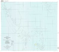
Ngerechur and Ngerkeklau islands stand as small outposts of solid ground amidst the expansive reef systems of northern Palau in this 2001 compilation. The landscape is dominated by the intricate patterns of coral reef structures, which form distinct maritime zones including the Ngebard and Ngkesol flats. Navigable passages like Toachel Ngerchelong and Ebil are vital features for movement between the Philippine Sea and the open Pacific Ocean. On the southern tip of the Ngkesol reef, Mutichur marks a rare named point of habitation or reference, while nearby Ruins on the smaller islands hint at earlier periods of human activity or historical settlement patterns in this isolated marine environment. The map provides a detailed view of the transitional waters where Kloul Euchel meets the deep sea.
Find a feature on this map
16 named features on this map. Tap any name to fly to it.
Don’t see what you’re looking for? This feature index may not catch every label — zoom into the map to look around manually.
Map Details
Editions of this 2001 Kayangel South Map
This is the sole edition of this map. No revisions or reprints were ever made.